
Contact for the resource
Canadian Wildlife Service, Environment Canada / Service canadien de la faune, Environnement Canada
Type of resources
Topics
Keywords
Contact for the resource
Provided by
Years
Formats
Representation types
Update frequencies
status
From
1
-
1
/
1
-
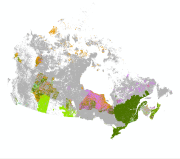
The national wetland layer contains wetland data compiled from the best available data from each region, classified by wetland type. Wetlands are mapped as polygons in geographic layers, which are integrated into a master geodatabase at the national scale.Information from each contributing dataset was classified based on the Canadian Wetland Classification System, which contains five main wetland classes (Bog, Fen, Marsh, Swamp, and Shallow Water) that represent the types of wetlands encountered in Canada. An additional category, “partially classified” was used to preserve boundary information for wetlands that could not be classified into the main categories with existing information.